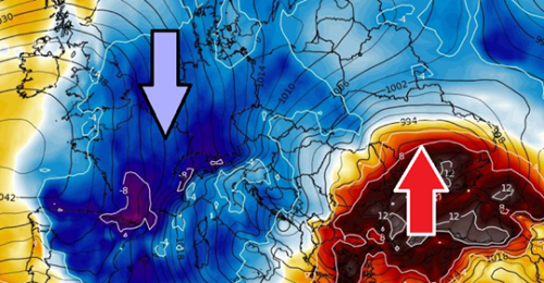
Seriously, there is an increasing potential for a pattern flip in early February. Finally, after many weeks we could say. Both global models GFS and ECMWF are hinting a strong upper-level ridge develops over the North Atlantic and result in an Arctic cold outbreak on its eastern side. This means the north-south oriented channel establishes a meridional flow across the western and central Europe, delivering much colder air mass from the Arctic region far south into the mid-latitudes. Let’s take a brief look at what is appearing on the forecast maps.
Lik og følg med oss på FB.
https://www.facebook.com/bestefarsklimasannhet/?ref=bookmarks
https://www.facebook.com/miniistid/?modal=admin_todo_tour
Maunder Minimum var den siste store Mini-Istid for 400 år siden. Nå starter Eddy Minimum. Historien gjentar seg.


